As inevitable as the sunrise, 2025’s Northern Hemisphere festival season has arrived. Of the music and performing arts festivals, Glastonbury is held in high regard, remaining to this day the largest greenfield festival in the world.
While renowned for the Pyramid Stage, top-tier performances, and embracing the hippy lifestyle, it’s also well known for tempestuous weather, which has featured more than a few times since its inception in 1970.
Time for Claros to Shine
In this blog post, we’ll explore some of the predictions made by MetSwift’s newly upgraded predictive model, Claros (version 3), which is due for release in June 2025. Through rigorous validation it has found to be even more skilful than version 2, outperforming alternative approaches up to at least two years ahead.
For example, compared to using historical averages, typical errors for hyper-local predictions were reduced by up 30% for seasonal predictions when averaged across regions of interest. Not only that, improvements of around 5% are seen at a daily time resolution, despite the challenge poised by the amount of ‘noise’ seen at that granularity. These gains accumulate greatly over time.
What’s more, these improvements are greater than what can be achieved using only long-term trends. Claros identifies where that trend is less likely to be relevant, providing useful predictions more often while reducing typical errors.
Impressively, when considering the ‘signal’ i.e. how often Claros is the right side of climatology with respect to observed outcomes, it’s consistently better (and by up to 6 times) whatever combination of hyperlocal or regional mean and single-day or multi-day time periods we look at.
Fair to say, we’ve been amazed by what this model is capable of. It has prowess that we can leverage to help anticipate what shenanigans the weather may get up to on certain future dates, like those of Glastonbury 2025.
Might It Be a Mud Fest?
Wet weather has rarely caused much disruption to proceedings, but it sure has a big impact on the experience of festival goers. Conditions in years past have ranged from a dust bowl (e.g. 2019) to a sorry impression of swampland (e.g. 2016).
Let’s see what Claros has to say about the prospects this year, and how they compare to climatology.
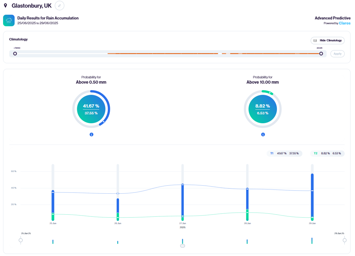
We can see from the overview dials that the probability of at least a little rain is just over 4% higher than usual, while the chance of over 10 mm – enough for muddy areas to form – is a little over 2% higher.
On the other hand, these aren’t large differences, and there’s still on average about a 6 in 10 chance of each day staying dry, with a less than 1 in 10 chance of over 10 mm rain.
However, if we look at the daily breakdown, these probabilities aren’t evenly distributed across the event dates. At least 0.5 mm is least likely on the Thursday, and most likely on the Sunday, while at least 10 mm is most likely on the Saturday.
Applying statistical theory, the predicted chance of all event days seeing less than 10 mm is 62.8%. So, about a 1 in 3 chance that at least one day sees enough rain to muddy the ground. There’s a reason the festival tends to be associated with mucky conditions!
What If Not Just the Music Booms?
We’ve checked out the wet weather risk, but what about a phenomenon that could interrupt proceedings? When you’re in the middle of a vast crowd, the last thing you want to see is a thunderstorm rolling in. Such was the case in 2005 for example, when several stages, including the acoustic tent, were struck by lightning.
Good thing, then, that Glastonbury isn’t located in a particularly thundery part of the world, or the UK for that matter.
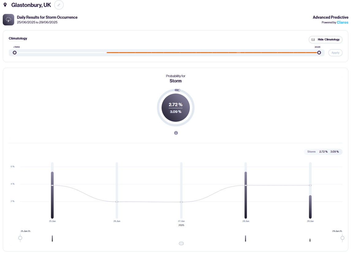
Historically, thunderstorms have occurred in just 2-4% of historical years depending on which date you look at. Claros suggests the risk will be higher than that on the Wednesday and Saturday this year, but still only 5.4% on each, which is just over a 1 in 20 chance.
Interestingly, adjusting the climatology used to 2000-2024, the average risk drops by about 0.5%, hinting at a long-term trend toward fewer thunderstorms.
Could the Wind Wreak Havoc?
When it comes to the many marquees that play their part in the festival, strong winds can be a problem, though rarely critical. Extra precautions are advised if the wind gusts to over 30 mph, but it would take exceptionally strong winds by British summertime standards to pose much risk of injury or worse via disintegration or collapse of marquees.
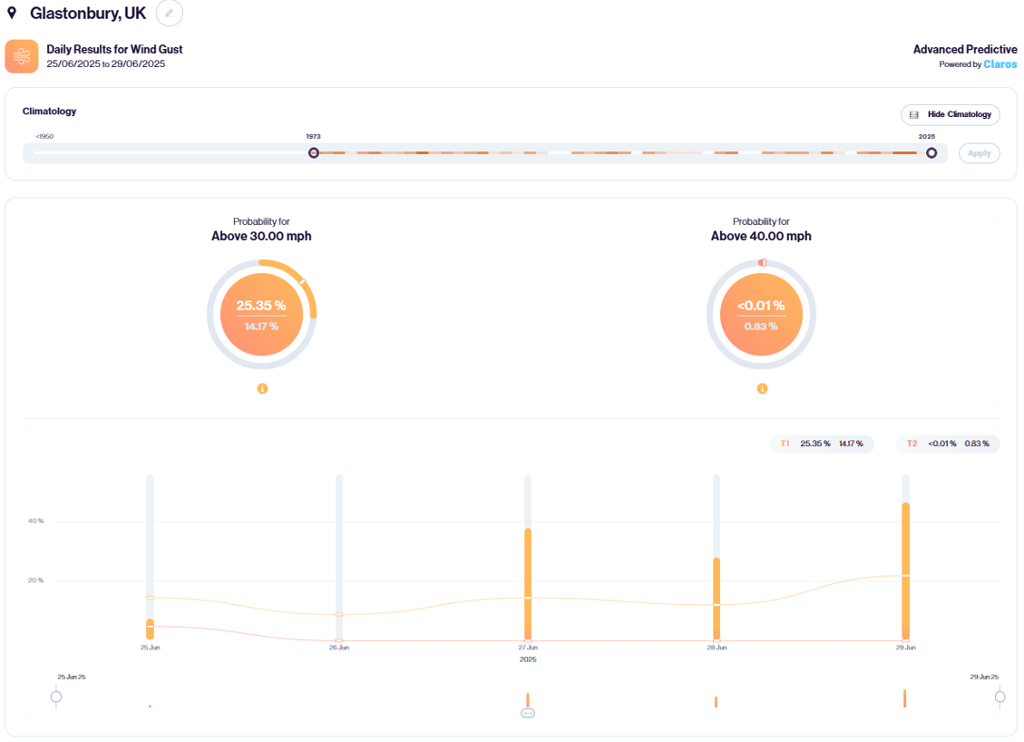
Claros indicates a much higher than usual chance of at least 30 mph wind gusts during the Friday through Sunday this year, but a miniscule chance of at least 40 mph. In fact, the official highest recorded wind gust during the festival is 36 mph in 1985. So, if suitable precautions are taken, the wind probably won’t cause disruption this year.
The most likely culprit for an exception would be a severe thunderstorm, an extremely rare event for Glastonbury, which has yet to occur during festival dates.
Unseasonable Chill or Summer Heat?
While the collective body heat of crowds and getting your groove on can act as a buffer, it’s not ideal if temperatures bear more resemblance to October than June.
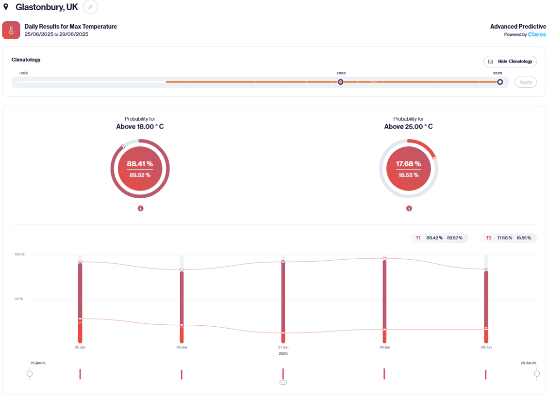
Fortunately, that’s rarely been the case historically, and especially in recent years, with almost 9 in every 10 festival days since 2000 having reached more than 18°C. Claros suggests no reason to expect much different in 2025.
Toward the other end of the spectrum, body heat can pose a problem if the weather turns hot, with the risks of dehydration and heat stroke reaching higher than would usually be associated with a given temperature.
Using 25°C as a benchmark for a hot feel to the weather, that’s been reached on just shy of 1 in every 5 days since 2000. This equates to about a 2 in 3 chance that at least one day in the festival reaches that temperature.
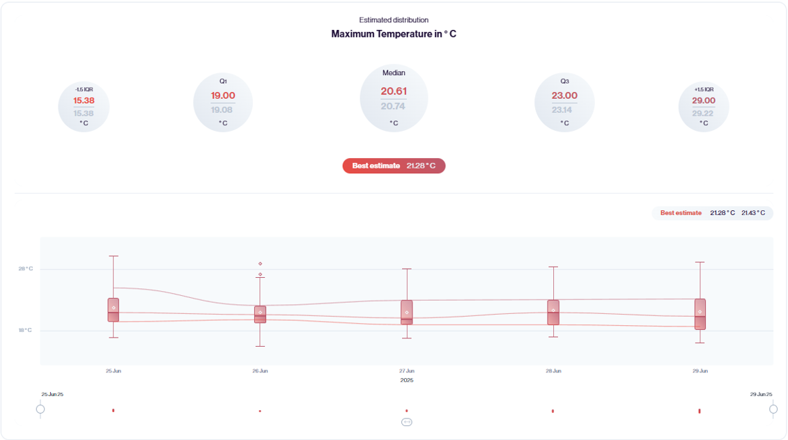
Claros suggests a slightly reduced chance of such temperatures this year. If we look at the estimated distribution, we can see that daily maximum temperatures in the range of 19-23°C are a good shout, with a best estimate of 21.3°C which many would consider ‘pleasantly warm’.
Wildfire Wildcard
With such a vast number of people crammed into a relatively small area, including extensive catering services with their appliances, the festival would pose a significant wildfire risk if not for good old heath and safety. It’s very likely that any fires that break out will be quickly contained.
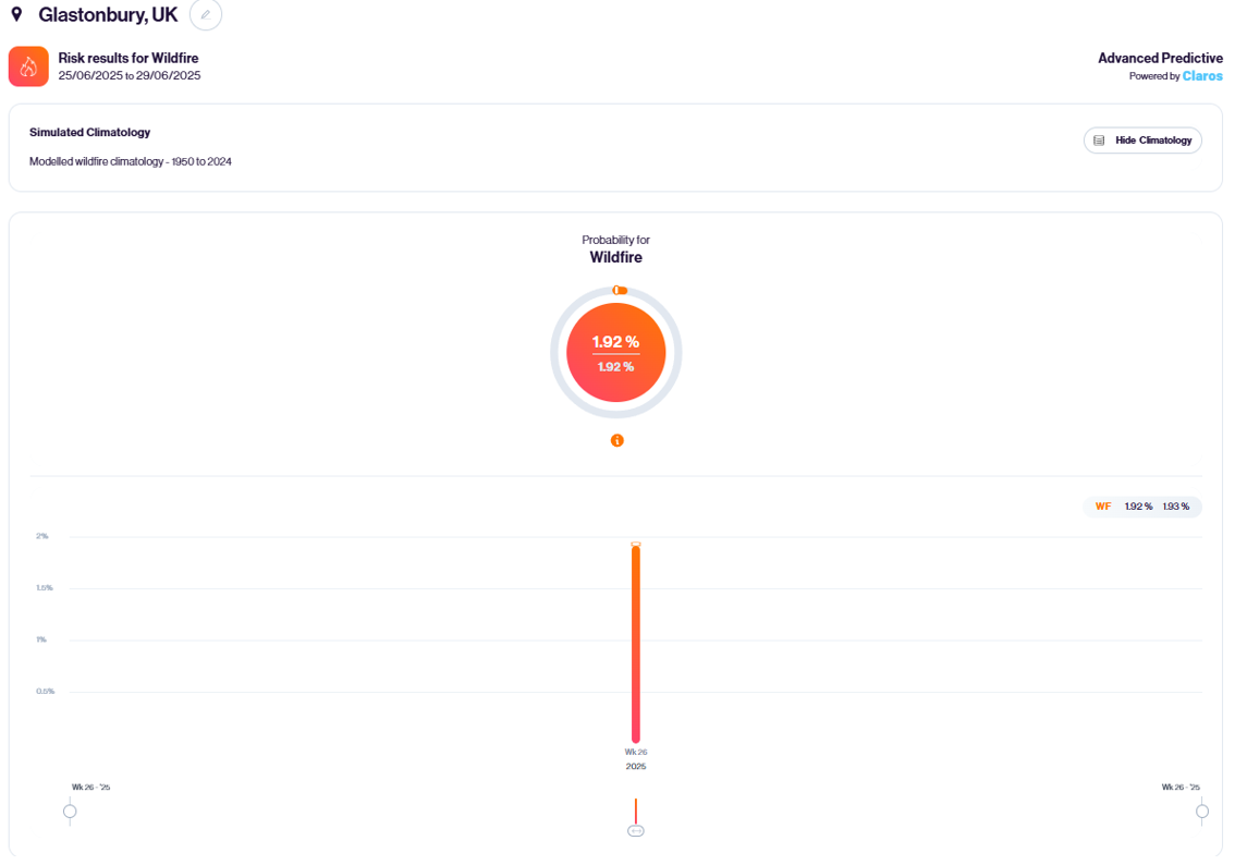
Helping matters is that weather conditions are only occasionally conducive to escalating a fire. Claros gives a just under 1 in 50 chance of the weather supporting growth to at least 10 square km coverage during Glastonbury 2025.
The Meteorologist’s Verdict
At this stage, I’m not seeing much cause for concern regarding this year’s festival. While Claros is leaning slightly toward some rainy weather featuring, there’s little sign of a washout. In fact, extended forecast modelling from the European Centre for Medium-range Weather Forecasts (ECMWF) currently favours a wetter north, drier south pattern across the UK.
What’s more, after some (perhaps very) wet weather during 12th-13th June, the week starting 16th is looking predominantly dry and warm, which should do a good job drying out any muddy patches in the runup to the event.
Temperatures might be something to keep a closer eye on. Exceptionally hot weather has recently become entrenched over the southwest of Europe and is frequently venturing as far north as France. It wouldn’t take much for some of that heat to pay southern England a visit, raising temperatures toward the 30s °C. On top of that, the breakdown of such hot weather would pose a risk of thunderstorms.
Be sure to stay up to date via my usual updates on social media (@peacockreports) as the event approaches. Here’s hoping the weather behaves itself!
James Peacock
Head Meteorologist at MetSwift
Featured photo by Anthony DELANOIX on Unsplash