Chances are, you’ve heard the term ‘sudden stratospheric warming event’ at some point in the past few years. Nearly every winter, it becomes a buzzword on social media, with news outlets latching on before long.
Put simply, it refers to sudden, dramatic changes to a cyclonic circulation in the stratosphere known as the polar vortex. One typically occurs every 1-3 winters, and it can have a big impact on surface weather patterns during subsequent weeks.
Major Sudden Stratospheric Warming Events
This blog will focus on a sub-category of sudden stratospheric warming event, generally referred to as ‘major’. This is where the polar vortex is so drastically disrupted that the mean circulation of the mid-upper stratosphere (i.e. 10 hPa pressure level), at 60 degrees latitude, is reversed from cyclonic to anticyclonic. This is generally a good way to isolate the sudden stratospheric warming events capable of significant, long-lasting impacts.
Even so, there is considerable variation between events in the regional detail of those impacts. This stems from specific details, such as the location of the polar vortex and the ratio of energy wave absorption to reflection by it (discussed later).
Overall, it’s best to think of these events as increasing the likelihood of cold weather in the mid-latitudes. Importantly, the distribution of that cold weather varies between them.
The composites used in the next two sections illustrate what proportion of historical dates meet the specified criteria for the daily means of sea-level pressure and temperature. Note that when talking about temperatures at least 1°C below average, even a probability of 50% is notably high.
Displacement Type Major Sudden Stratospheric Warming Events
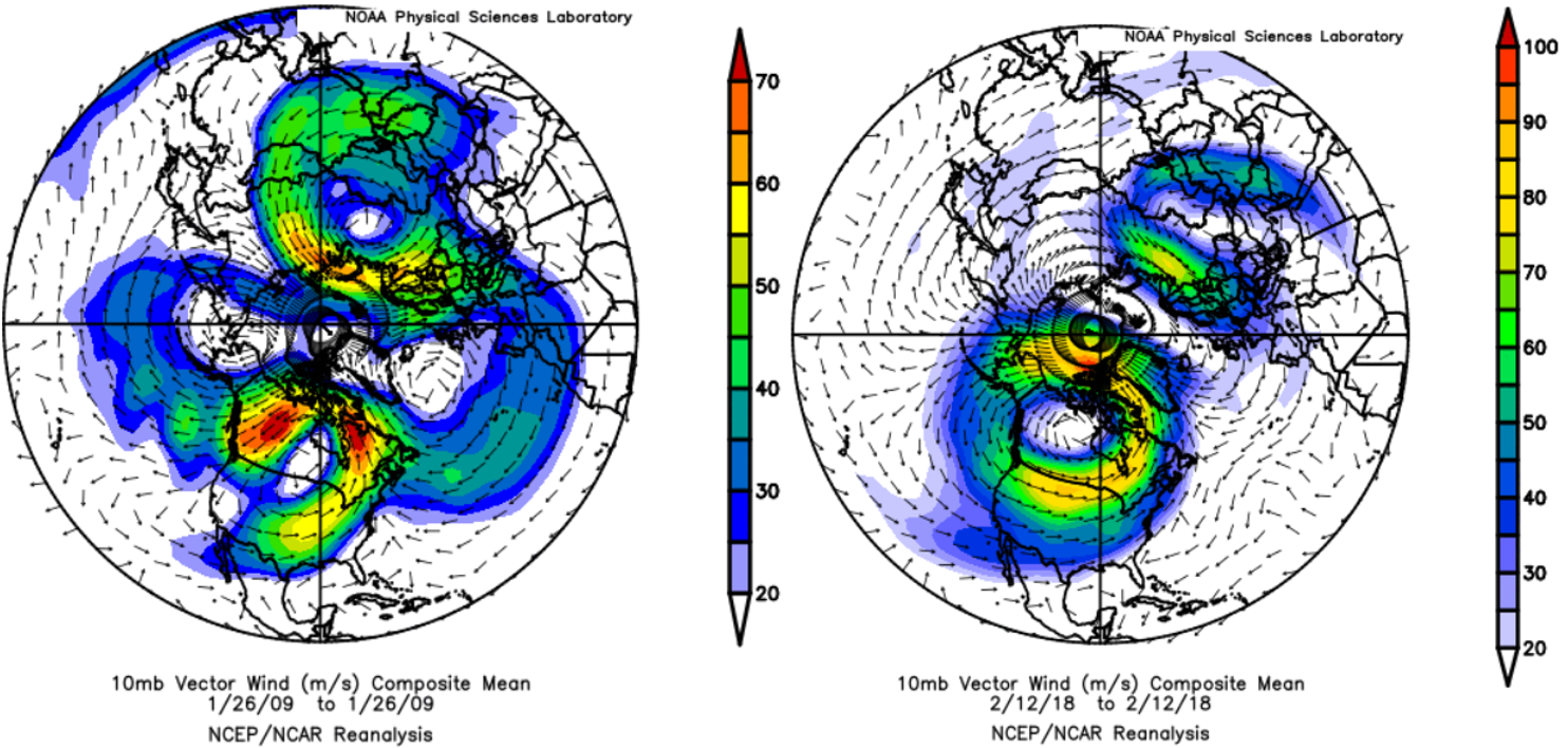
This type of major sudden stratospheric warming event sees the polar vortex wholly shifted away from its usual position. In the northern hemisphere that means movement away from the high Arctic. A couple of recent examples are shown below. The polar vortex can be identified by the ring of higher wind speeds (green-yellow-red shading).
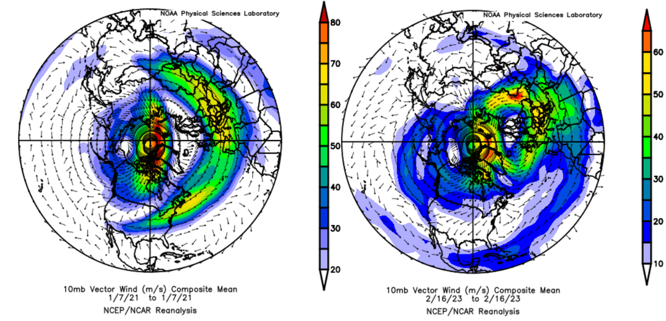
Notice how the polar vortex is displaced toward Europe in both cases but has differing structure. There’s often some ‘stretching’ of the polar vortex during these events, but it was far more pronounced in 2021’s. Both events led to cold weather outbreaks in the US, but the 2023 event much more so.
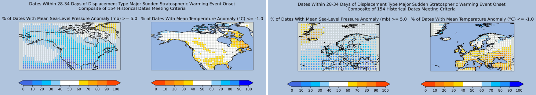
The Composites
In the 2nd week after a displacement type event, composites suggest a high latitude blocking pattern has about a 50% chance of establishing. When it does, high pressure tends to locate between Greenland and Svalbard.
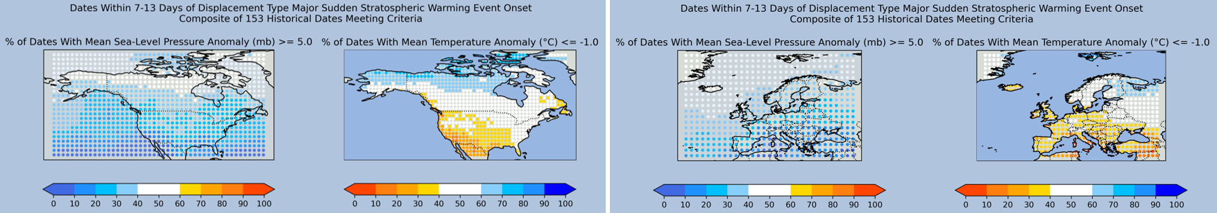
This increases the likelihood of colder than usual weather across much of Canada and Alaska, most of all in the north, along with north-eastern Europe.
There isn’t much change in the composites for the 3rd and 4th weeks. In North America, the cold weather probability in Canada reduces slightly for the 3rd week, only to recover for the 4th. Meanwhile in Europe, it expands toward central Europe, but the highest propensity for cold weather remains in the northeast.
For the 5th week, the high latitude blocking signal increases around Greenland, peaking at near 70% by Iceland. In North America, there is a reduced signal for anomalously cold conditions in Canada and Alaska. In Europe, the cold weather signal becomes more concentrated in the northeast.
The 6th week sees the main high latitude blocking signal shift eastward slightly. There’s also an increased frequency over Canada (near 50%). The composite suggests a 50-60% probability of cold weather across most of North America. Meanwhile in Europe, the cold signal remains focused over the northeast, but the central region now has a near 50% frequency.
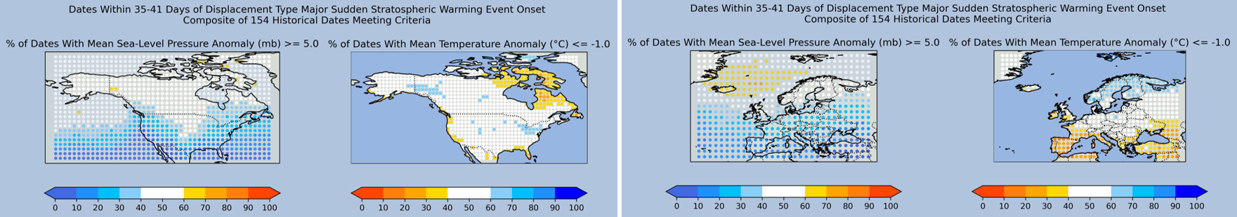
For the 7th week, the cold signal drops off for both the western US and central Europe. This change spreads further northeast across both continents for the 8th week.
The effects of a displacement type major sudden stratospheric warming events tend to take 4-6 weeks to finish propagating down and influencing surface weather patterns. So, it’s no surprise to see the cold weather signal diminish so much after the 6th week.
Now, what about the other distinct event type?
Split Type Major Sudden Stratospheric Warming Events
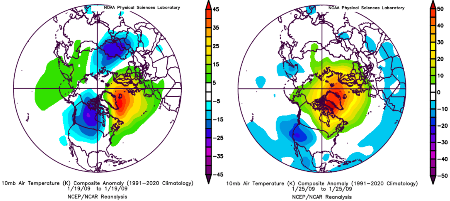
You won’t be surprised to read that this type of event involves the polar vortex being split into two (or, rarely, more) child vortexes. Two examples are shown below, with the left-hand one (January 2009) among the most impressive on record.
The January 2009 event featured ‘anti-vortexes’ (anticyclonic circulations) so powerful that their wind speeds can clearly be seen on the composite, as the pair of clockwise circulations. The child polar vortexes are situated over North America and northern Asia. The February 2018 event was similar, except for the vortex on the Eurasian side being closer to Europe.
Despite being not quite so impressive in the stratosphere, the 2018 event had the more dramatic surface weather impact, a potent mid-late February into early March cold spell in Europe widely referred to as ‘The Beast from the East’.
Since 1958, all but one of the displacement type major sudden stratospheric warming events has moved the polar vortex to sit above somewhere between the North Atlantic and northern Asia. Meanwhile, an anomalous anticyclone occurs above somewhere between the North Pacific and North America.
The Composites
In line with our dynamical understanding of how the vertical evolution of split type events differs to displacements, composites suggest a quicker response of surface weather patterns.
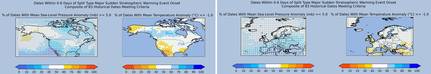
There’s also another major difference: the high-latitude blocking signal has two centres (both near 50% frequency). One over Alaska and western Canada, the other spanning near Iceland to Svalbard. The suggested probability of anomalously cold weather is 50-60% across much of Canada along with the central and north-eastern US. A few spots in Canada are at 70%. In Europe, frequencies of at least 50% cover a wider area than seen in any week for displacement type events. Only in Iberia, Ireland, and the UK do they remain lower.
The 2nd week sees little change in the composites. In the 3rd, the cold signal in North America becomes more concentrated over north-western Canada.
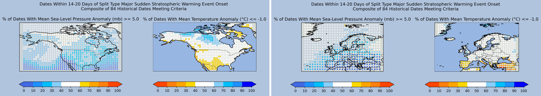
Meanwhile in Europe, it extends across the UK and Ireland, with a peak near 60% frequency over England.
The 4th week sees the area of 60-70% cold weather frequency extend slightly south-eastward in Canada. Meanwhile in Europe, it generally reduces slightly in the west and increases in the northeast, peaking near 70% in northern Scandinavia.
For the 5th week, the peak cold signal in North America heads for the Canadian Arctic Archipelago. The frequency is still 50% across the rest of central and eastern Canada, plus the central-northern and north-eastern US.
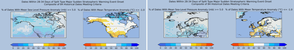
In Europe, the cold weather frequency generally reduces. Throughout these first 5 weeks, the high latitude blocking signal has yet to reach more than 50% anywhere within the two continental regions. Yet it’s well documented that such blocking usually features in the wake of major SSW events. From this we can infer that these probabilities are held down by variation in the location of the blocking high. Sometimes it’s nearer Europe, sometimes North America. Other times it moves between the two, and at a pace which varies between events.
The 6th week sees a widespread slight increase in cold weather probability in both continents. A hint perhaps that the impacts of a split type event tend to occur in two distinct stages. If so, the second one appears to rarely bring cold weather to the western reaches of Europe.
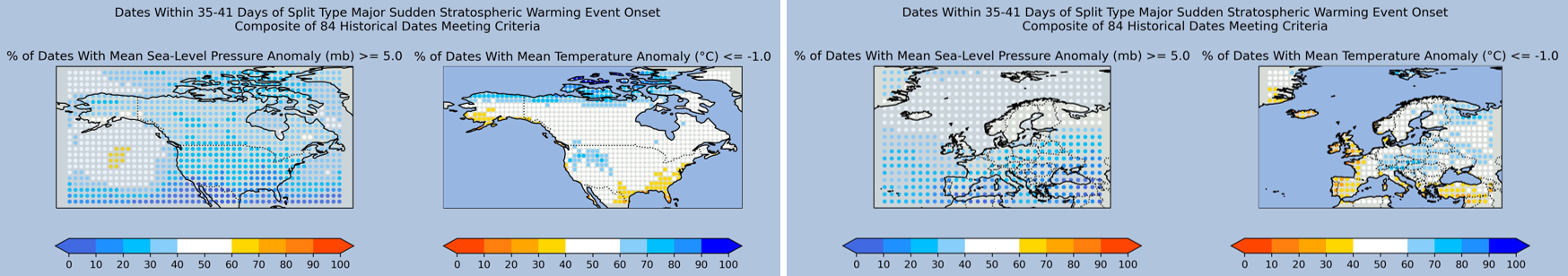
The composites for the 7th week feature the strongest signal yet for cold weather in North America. Impressively, a wide swathe from north-eastern Alaska to around the Great Lakes has a 60-70% suggested probability. Meanwhile, an at least 60% probability of high latitude blocking finally appears, located just to the north of Europe. There’s a strong cold weather signal for easternmost Europe and to a lesser extent Scandinavia.
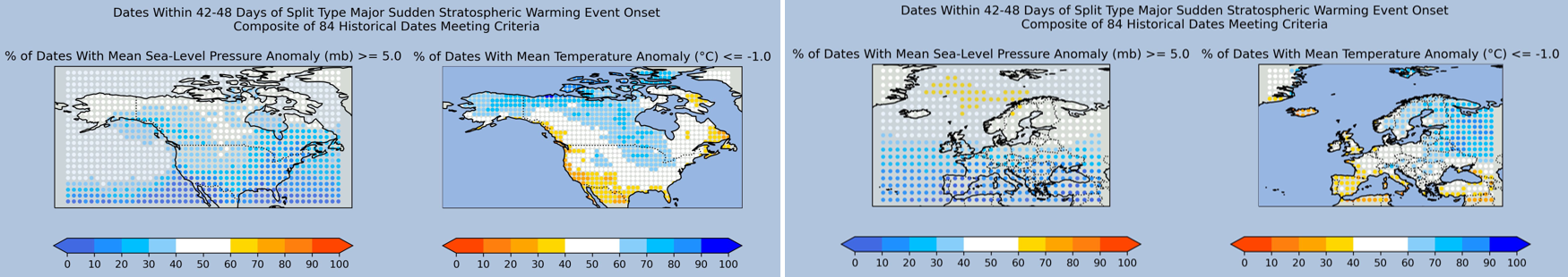
In the 8th week, the frequency of cold weather reduces for most of North America and Europe.
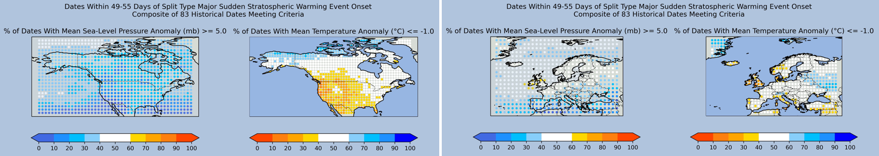
This suggests a similar time taken to displacement type events for the effects to finish propagating down from the stratosphere.
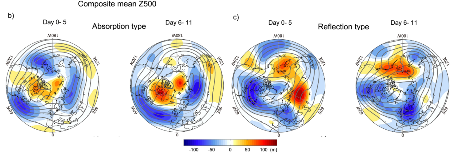
The Absorption Versus Reflection Problem
Sudden stratospheric warming events are broadly speaking the result of waves in the troposphere (lowest layer of the atmosphere) dispersing energy into the stratosphere (the one above). The more energy a medium such as air has, the higher its temperature. So, we see a pronounced warming of the stratosphere – hence the name used for the event.
As shown in the example below, this warming tends to emerge above the mid-to-high latitudes (50-70 degrees) and then move toward the polar region.
This movement is the result of the energy being absorbed into the polar vortex’s circulation. If it progresses far enough, the polar vortex is forced to vacate from the polar region and a major sudden stratospheric warming event (or close to it) has occurred.
How far it progresses depends on how much energy is absorbed as opposed to reflected by the polar vortex. This is an unhelpful complication because it has a strong bearing on the impact that a major sudden stratospheric warming event has during the subsequent 4-6 weeks.
At one extreme, there are events where almost all energy is absorbed. This tends to keep the polar vortex in a highly disrupted state for at least a month. It leads to the highest probability of cold weather affecting mid-latitude regions such as North America and Europe.
At the other, much of the energy is reflected. In that circumstance, after being briefly highly disrupted, the polar vortex rapidly recovers. This is because the reflected energy warms the stratosphere over the mid-latitudes, which encourages cyclonic spin – which is a key characteristic of the polar vortex – over the polar region. The increase in mid-latitude cold weather probability tends to be short-lived and focused over North America.
The stark difference is extensively detailed in this 2015 paper by K. Kodera et al. and was further explored in 2024 by K. Yessimbet et al.
Late 2025: A Time for Reflection
At the time of writing (24th November 2025), forecast guidance is in strong agreement that a reflective type sudden stratospheric warming event will occur at some point within 24th-28th November. This is evident in zonal mean zonal wind predictions by the European Centre for Medium Range Weather Forecasts’ extended ensemble model (see below-left). After being near or below zero through 28th November, this mean wind is predicted to increase rapidly until about a week into December.
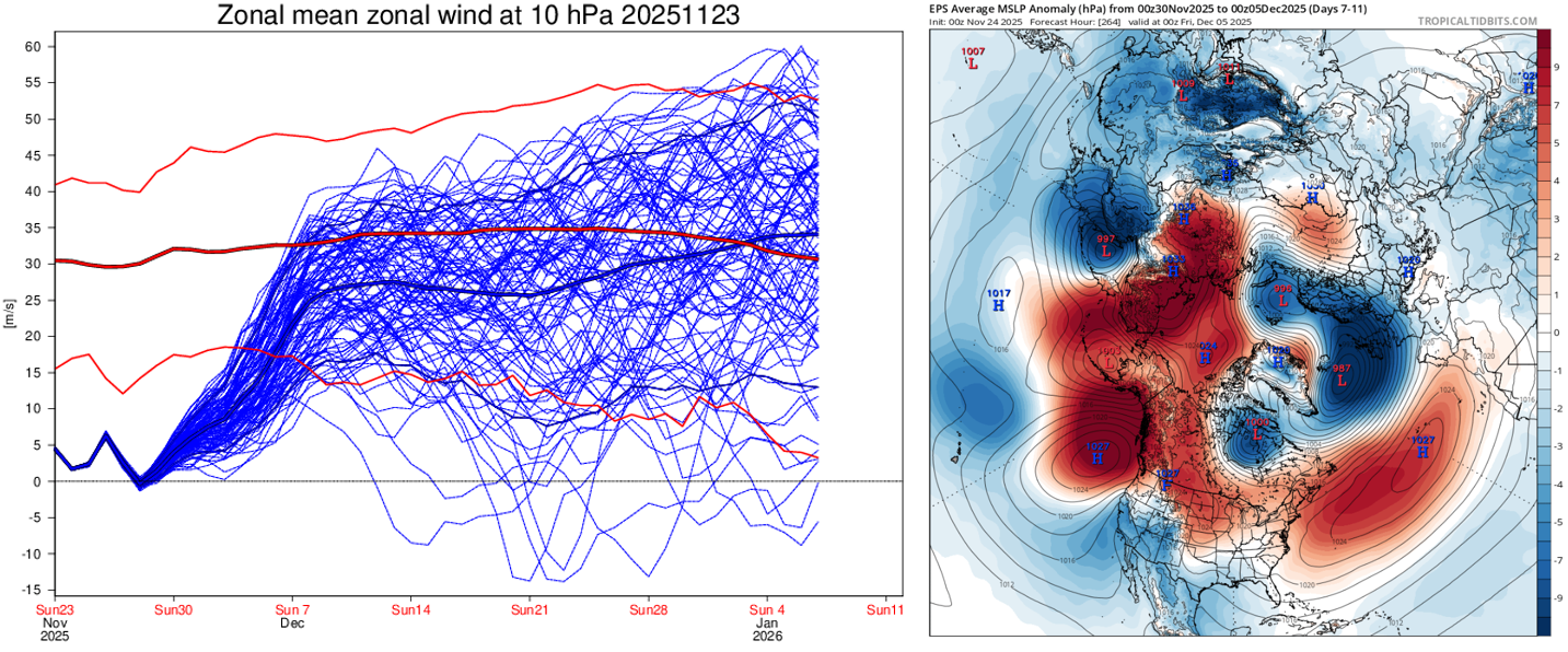
For an absorptive type sudden stratospheric warming event, the predicted mean wind would instead remain near or below zero for at least a week.
We should therefore expect a period of blocking high pressure over the Pacific-North America sector in the first week or so of December 2025. Meanwhile, the opposite can be anticipated for the Atlantic-Europe sector; very westerly-driven with deep low pressure systems on the scene.
That’s precisely what numerical weather prediction models are currently forecasting (see above-right). This means a large swathe of Canada and the US will likely experience a pronounced cold spell lasting at least a few days, perhaps as long as a week in places.
By contrast, little in the way of cold weather is likely in Europe, with the northwest often wet and windy, and a more benign picture further south and east.
So, there you have it: A major sudden stratospheric warming event doesn’t automatically translate to cold weather in the mid-latitudes – especially Europe, as 2025 is likely about to demonstrate.
James Peacock MSc
Head Meteorologist at MetSwift